
New Highway 417 interchange among options in The Nation’s transportation plan
Road changes, safer walking and cycling routes, and a look at public transit form part of the municipality’s long-term planning. Residents can comment until Nov. 2.
A possible new Highway 417 interchange, an additional road corridor and safer walking and cycling routes are among the changes being considered as The Nation prepares for growth in Limoges, St-Albert and St-Isidore.
Recommendations displayed at an Oct. 6 open house in Limoges set out how the municipality could address future traffic pressures while making it easier to reach schools, recreation facilities and other destinations without a car. The proposals are part of The Nation’s first Transportation Master Plan, with public comments still being sought before the plan is completed and considered for adoption.
“Nothing’s written in stone right away, but again, this is part of the process, is to get public feedback,” Mayor Francis Brière said.
The study’s central recommendation is to combine road improvements with investment in walking, cycling and transit. Its evaluation says existing plans alone are insufficient, while expanding roads by themselves would be costly and would do less to broaden travel choices.
Growth puts pressure on Limoges Road
Limoges Road is the main north-south connection between the village, Highway 417, Calypso Waterpark and Embrun. The study identifies waterpark traffic and future residential growth as major challenges for that corridor.
Its modelling uses housing and population projections prepared for the 2025 Water Master Servicing Plan, including an assumption of 150 additional housing units a year, or 3,750 by 2051. Those are planning projections used to estimate travel demand, rather than a promise that each development will proceed on that schedule.
The road-analysis board concludes that the existing Limoges interchange and the Limoges–Calypso intersection would be unable to accommodate projected future travel demand even if fully upgraded. It identifies an alternate connection to Limoges and the waterpark as important to supporting future residential growth.
A new Highway 417 interchange between Limoges and Casselman is one option. The study lists potential benefits including another route to the waterpark, reduced traffic demand on Limoges Road, less truck traffic there and better access to Innovation Park employment lands.
The same board identifies significant financial costs and possible wetland impacts, depending on the alignment. Further studies and Ministry of Transportation approval would be required. The displayed material provides no price tag, approved interchange location or construction date.
An already-planned north-south collector road between Savage Street and des Pins Street would provide another route through Limoges. The current alternatives examine extending that connection south, building a new collector or upgrading Gagnon Sideroad. The recommendation map labels the southern extension’s alignment as undefined. The alternatives also flag environmental and financial implications and an additional at-grade railway crossing requiring CN approval.
Intersection changes and a wider southern approach
The recommendations include widening Limoges Road to four lanes between the Highway 417 eastbound-ramp intersection and Calypso, along with turning-lane and signal changes at the existing interchange.
At Savage Street, the study proposes either a roundabout or traffic signals with auxiliary turning lanes. At des Pins and King streets, it recommends realigning the offset intersection, adding signals and providing turning lanes. At Calypso, turning lanes or a roundabout are identified; a roundabout or signals are also proposed at Limoges and Russland roads.
These choices carry different trade-offs. The alternatives board says roundabouts can slow traffic and reduce more severe collision types, but may require more land and be harder for pedestrians and cyclists to navigate. Signals can better accommodate pedestrian and cycling crossings. The ultimate choice requires agreement among The Nation, Russell Township and the United Counties of Prescott and Russell.
The study also calls for consideration of traffic calming and speed management, and access rules intended to keep entrances safe and limit additional access points onto major roads.
Making short trips possible without a car
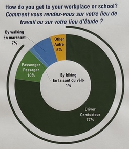
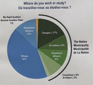
The February online survey received more than 200 responses. Among respondents, 77 per cent said they drove to work or school and 42 per cent identified Ottawa as their work or study destination. Fifty-eight per cent disagreed that the transportation network was accessible and inclusive. These are findings about the people who answered the survey, not a demonstrated representative sample of all residents.
Recurring comments sought more sidewalks, bike paths and paved shoulders, better maintenance, age-friendly planning and safer ways to travel without a car. The survey also recorded interest in transit to Ottawa and between villages.
In Limoges, the study identifies gaps in sidewalks, difficult connections to St-Viateur school and The Nation Sports Complex, inadequate cycling protection on Limoges Road and an unsafe connection across Highway 417.
Recommendations include a multi-use pathway or sidewalk north to the school and sports complex, protected cycling facilities from Savage Street south to Calypso and the waterpark, and coordination with the province on a separated multi-use crossing of Highway 417.
Other proposals would extend sidewalks south to Calypso and along Calypso to the waterpark. In existing and future village cores, sidewalks on both sides of streets would support walking. On local streets with safety concerns, the options include a sidewalk on one side, restricting parking to one side, and traffic calming or speed management.
The cycling recommendations also call for completing planned multi-use pathways and working with the counties to pave shoulders on regional cycling routes, improving connections between villages.
Different needs in St-Isidore and St-Albert
The study uses estimates approaching 1,000 future housing units for St-Isidore and 320 for St-Albert, divided among short-, medium- and long-term development. These are growth assumptions for the transportation analysis.
The assessed road intersections marked on those village maps are shown as requiring no intervention. Both communities nevertheless have recommendations to consider local traffic calming and speed management.
In St-Isidore, the pedestrian proposals include improving the connection to the arena frontage, providing sidewalks to Caledonia Manor and improving the school crossing. A school-crossing improvement is also recommended in St-Albert.
Transit and the rules for future roads
A supporting-policy board proposes a transit feasibility study to examine reintroducing municipal or regional service, including a commuter service to Ottawa. The open-house material does not set out a selected service, route, fare or start date.
The broader policy work covers sidewalk and cycling standards, truck routes, transportation-impact assessments, subdivision design, traffic calming, intersection controls and protecting land for future intersection changes. Draft road cross-sections show how space for walking and cycling could fit into urban and rural road designs, including paved shoulders on rural collectors.
Brière said the municipality needs long-term goals to guide spending as its communities grow. Adoption and implementation planning remain ahead.
The next steps displayed at the open house are to review public feedback and release a draft report for a 30-day public review before the end of the year. The current round of comments closes Nov. 2.
“I’m hoping that we can find solutions that are long-term that work for everybody,” Brière said.